Research paper: Vasudev D., Goswami V.R., Srinivas N., Syiem B.L.N., Sarma.A (2021) Identifying important connectivity areas for the wide-ranging Asian elephant across conservation landscapes of Northeast India. Diversity And Distributions 00, 1-17 https://doi.org/10.1111/ddi.13419
Blog Author: Vinni Jain
Key Highlights:
- Animal movement and connectivity across vast distances is critical for conservation and ecosystem functioning
- Scientists conducted a study in Northeast India to identify important connectivity areas for the endangered Asian elephant, using movement models and crowd-sourced data
- They interviewed 1,184 respondents to get data on elephant habitat use and satellite maps to understand how different land-use types prevent or facilitate their dispersal
- The results show that elephants prefer areas near forests with high vegetation and fewer people
- Authors have mapped important connectivity areas and highlighted the importance of forests, as well as the contribution of other land-use types for elephant dispersal
In today’s world, dispersal across large landscapes is increasingly difficult for wide-ranging animals. Animal movement is often blocked by human-made barriers such as crops, settlements, roads, railways, and other infrastructure, and facilitated by forests and other hospitable land-uses. Maintaining connectivity between different populations and habitats is critical for healthy ecosystem functioning. To do this, we need to understand how animals move, which types of barriers affect movement the most, and where and how connectivity can be improved for different species.
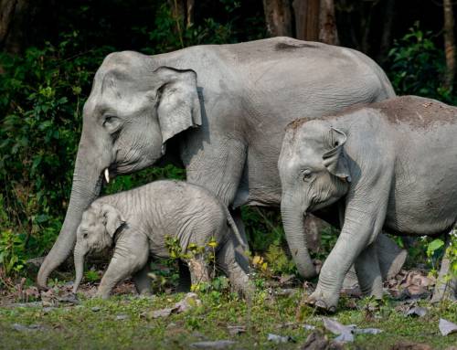
In a study published in Diversity and Distributions, scientists led by Dr. Divya Vasudev and Dr. Varun Goswami used crowd-sourced data to identify priority connectivity areas for Asian elephants across 21,210 km2, covering areas in the states of Assam and Meghalaya in Northeast India. The study area included two Elephant Reserves (ERs) – Kaziranga-Karbi Anglong and Dhansiri-Lumding – estimated to host approximately 2000 elephants. This region consists of grasslands, moist evergreen forests, and deciduous forests embedded in a matrix of rice paddy fields, tea and sal plantations, and human settlements.
The team of scientists conducted 1,184 questionnaire surveys across areas with high human population density to assess how frequently elephants use different parts of the landscape, and to ascertain the levels of human-elephant conflict. Using elephant movement models and geospatial analysis, they analyzed the influence of linear infrastructure, conflict, and other variables on elephant movement.
The results show that, unsurprisingly, areas with high vegetation that lie close to forests and have less humans provide the least resistance to elephant movement. Outside forests, elephants used tea plantations the most, followed by closed-canopy plantations and open cropland. The scientists found that elephants, with their high cognitive and perceptive abilities, tend to move using information about the surrounding landscape rather than randomly. They did not find any clear link between elephant connectivity, human-elephant conflict, and linear infrastructure.
These results highlight the importance of forests as corridors for elephants as well as the supporting role of other land-use types that contain vegetation. Future conservation efforts should focus on securing forests that serve as important linkages while also improving areas where movement is currently difficult, for example by increasing vegetation cover. Despite a shortage of existing data on connectivity, this study was able to use crowd-sourced data to generate detailed maps showing key connectivity areas for a globally endangered species. A similar approach can be applied to other wide-ranging species in tropical forest landscapes for regional conservation planning.