Research Article: Karanth, K. K., Gopalaswamy, A. M., DeFries, R., & Ballal, N. (2012). Assessing patterns of human-wildlife conflicts and compensation around a central Indian protected area. PloS one, 7(12), e50433. https://doi.org/10.1371/journal.pone.0050433
Blog Author: Aparna Rao
Key highlights:
- The study examines human-wildlife interactions in agricultural settings near Kanha National Park, located in Madhya Pradesh, focusing on crop damage and livestock predation.
- Researchers used surveys and interviews to gather self-reported data on conflict incidents, covering approximately 60% of the local population.
- High rates of crop loss correspond to proximity to water sources and protected areas, while grazing cattle inside forest areas was strongly associated with higher livestock losses.
- Local communities employed varied mitigation measures like night guarding and physical barriers, though there was limited compensation reporting.
- The study directs conservation efforts strategically towards high-conflict hotspots to elevate awareness and to implement robust conflict management and reporting systems that drive impactful change.
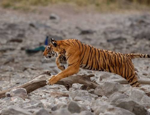
Indian forests support a rich diversity of wildlife that often comes into conflict with people living nearby; while some species are generally tolerated, tolerance drops sharply for those perceived as more dangerous. Among different types of impacts, crop damage is the most common and severe, outweighing losses of livestock and human injuries. Researchers and field assistants from the Centre for Wildlife Studies, together with their collaborators, conducted this study to map key factors influencing human–wildlife conflict and mitigation. They analysed agricultural and population characteristics, as well as differences in loss patterns, particularly between crop damage and livestock predation.
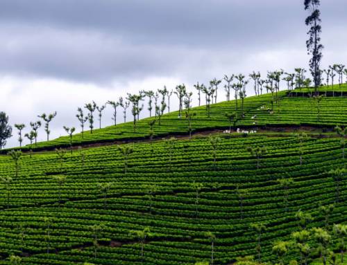
Kanha National Park, a major tiger reserve in India, is surrounded by a large buffer zone and supports diverse predators and herbivores. This buffer also sustains local livelihoods such as grazing and resource collection, making it ideal for comparing human–wildlife conflict inside and outside the park. Researchers used sociological surveys and interviews, covering about 60% of the local population.
Household loss was assessed using only the most recent conflict incidents to avoid memory bias pertaining to older events. Most respondents were men with limited formal education and primarily engaged in agriculture, growing a variety of crops. Crop losses were attributed to multiple species, mainly herbivores, along with some carnivores, primates, and peacocks. About 64% of households experienced more than five incidents per year, and losses increased with the number of crops grown annually.
Grazing cattle inside Kanha was strongly associated with higher losses. Crop damage in and near Kanha declined with increasing distance from protected areas, while households closer to water sources experienced greater losses. Communities relied on local mitigation measures such as night guarding, scaring devices, and closer supervision of livestock. Physical barriers and guard animals were linked to lower cattle losses, with physical barriers being the most commonly used method to prevent livestock predation.
Reporting of crop loss was far lower than the actual number of conflict incidents, and only a small proportion of affected households received compensation. While crop-loss reporting was similar inside and outside the buffer zone, livestock-loss reporting was higher within the buffer. Crop loss also increased with longer cropping periods and closer proximity to Kanha.
The mapping of compensation distribution provides a greater picture of the problems by identifying the major factors connected to self-reported crop and livestock losses. Additionally, the researchers found spatial and temporal variation in the losses due to human-wildlife disputes. Many human–wildlife conflict studies suffer from weak spatial sampling and limited modeling, which reduces their usefulness for on-ground conservation planning.
By identifying clear conflict “hotspots,” this study provides managers with practical insights to target conservation efforts more effectively. For instance, villages and households in high-risk areas can be better informed about conflict prevention, mitigation measures, and systematic reporting of losses, making conservation actions more efficient and impactful.
The study relied mainly on self-reported survey data rather than direct observation, raising the possibility of over-reporting, though no systematic bias was evident across the large sample. While the survey size reduced potential bias, the authors emphasize the need for real-time, location-based monitoring to better assess conflict events, mitigation measures, and compensation processes. Despite these challenges, the approach of identifying key risk factors and mapping conflict spatially is widely applicable and can be adapted to other landscapes where people and wildlife coexist, helping conservation resources and funds to be targeted more effectively.
To access the original article, click here.
Keywords: Human-Wildlife Conflict, Crop Damage, Livestock predation, Kanha National Park, Spatial Mapping, Conflict Hotspots, Landscape-level Analysis, Mitigation Measures